Heavy-Haul Route Map
For use with American Truck Simulator by SCS and my heavy-haul trailers modification.
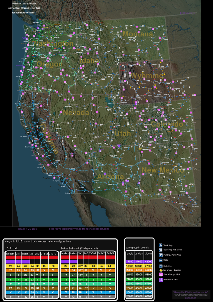
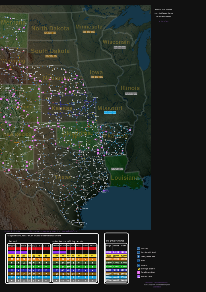
I wanted to add more depth for heavy haul by observing route and bridge restrictions for weight and length limits. So, I looked up state restrictions relevant to in-game highways and created a map and weight charts. Colored routes help recognize weight and length limitations as noted within the included charts. For simplicity the charts show maximum cargo weight per trailer instead of overall gross vehicle weight (GVW). I found limited or incomplete information for some states including California and Montana. Additionally I included icons for locations of in-game weigh stations and rest areas.
heavy-haul routes for non-divisible loads
In summary:
- when using trailer combinations which include a jeep (all triples and the 2+3 double) may travel with heaviest available cargo on green, blue, and gray routes
- 8x6 and 8x4 truck may take most cargo per trailer nearly anywhere on green, blue, and gray routes
- when using a 6x4 truck observe the chart to find cargo or best trailer for the planned route
- otherwise watch for weight-limited violet, yellow, and orange routes
- observe overall length limits
- when using 3+1 trailer recommend 8x4/8x6
contents
- US West map
- legend
- US West routes of note
- US Central map
- US Central routes of note
- length limits and chart
- List of other player-created maps
US West
updated 2026 February 10
Click/Tap image for high-resolution 5080 x 7800 (3.4 MB) jpeg image. Decorative topographic background from shadedrelief.com.
map without topography / black background
legend
The first three charts provide approximate cargo weight in US tons (1 US ton equals 2000 lbs) per semi-truck type (6x4 or 8x6/8x4) and trailer combinations where trailers listed by axle groupings. For example, 3+1 is a tridem with a single-axle booster, and 2+3 is two-axle jeep with tridem trailer. Tri-drive or 8x4 day cab may add a ton or two when using single tridem trailer or with booster (3+1). I also included the axle-group chart for reference as a basis for the cargo charts. Some of these axle-group values (in pounds) differ from real-world values which also vary between states. For simplicity I combined similar overweight limits with same color.
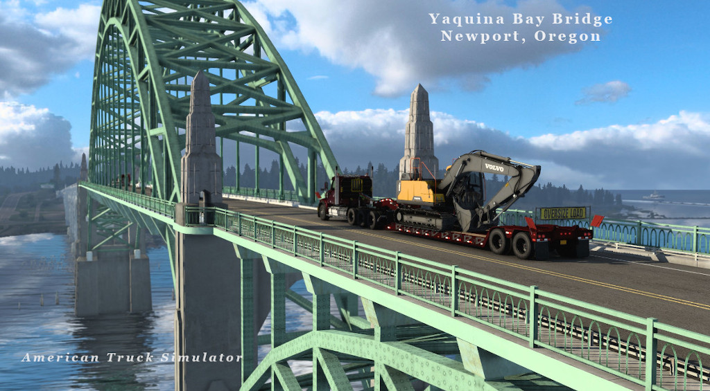
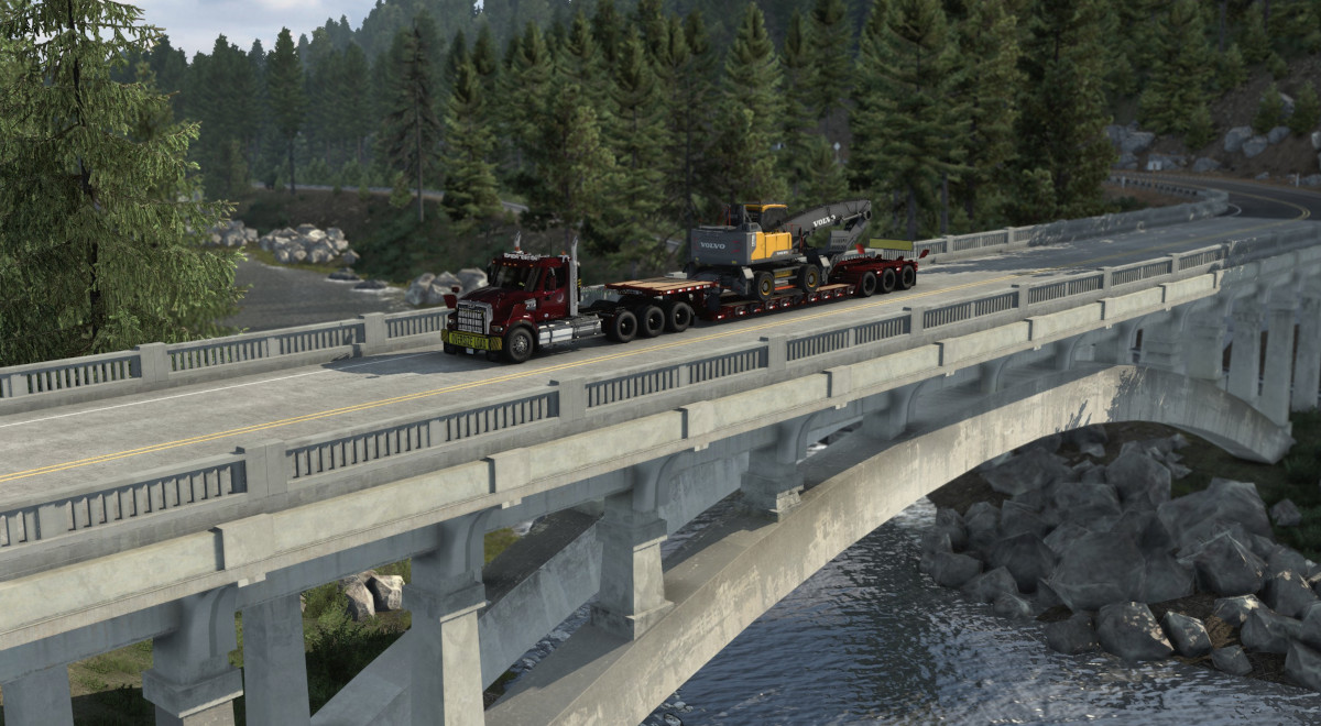
Yellow, orange, green, blue, and gray colored routes indicate maximum permitted weights exceeding national bridge formula limits. For instance a legal load allows a maximum of 34000 lbs on a tandem group (as noted in the axle-group chart with violet color) and yellow routes allow by-permit travel up to 36000 lbs. Yellow, orange, and violet routes generally apply only to bridges. Instead of just coloring the bridge I colored a longer section of highway for easier reading. Some bridges not depicted in game, and for bridges I have confirmed in game indicated in colored text the name of bridge or crossing. Violet colored bridges limited to state-legal GVW, or in some cases permit-limited GVW provided enough axles to meet bridge formula. For these an icon indicates the GVW limit. See below for in-game examples of violet-colored bridges.
Magenta icons denote length or width limits. In many cases oversized loads exceeding the indicated length may take these routes when accompanied by a pilot (or escort) vehicles such as with Special Transport add-on DLC. For these routes the value should be assumed with an oversized permit and legal lengths may be shorter. Such as in Idaho the blue routes with pink-95 icons indicate maximum permit length of 95 feet overall, but the legal overall length is 75 feet with maximum trailer length of 48 feet. New Mexico requires escort for lengths over 90 feet which limits trailers to singles or with booster. Width limits denoted with a W-number icon where the number is in feet allowed without an escort. Remember the trailer is about 8.5 feet wide, so a W8.5 would indicate any overhang requires an escort vehicle.
Red routes mark restricted or limited access such as a national park limiting access to trucks servicing the park or other restrictions. Notice the red in Colorado on US-550 south of Ouray which marks a tunnel where trucks are not allowed to take loads through. In California I marked “no road” for the section of highway after the real-world road ends within steep mountains.
Green tinted background states represent states participating with Western Regional Agreement for issuing permits for overweight vehicles for interstate travel - see the Western Regional Permit Desk Guide. The charts show the weight limits in matching color. My heavy haul trailers modification targets these weight limits for limiting cargo when using an 8x4 truck or any truck-trailer combination including a jeep.
Within the charts the ∀ symbol means, as pertaining to my modification, may take any cargo available for that trailer.
Additionally I marked weigh stations and identified sleep areas by type——truck stop denoted by P-over-truck, rest area denoted by picnic table, and motels marked with bed symbol. Besides the stand-alone motels, I consider a motel adjacent to a truck stop as an accessible motel and marked them with a bed-over-a-truck icon. For heavy haul I primarily drive a day cab returning to the garage most nights. Knowing motel locations helps plan for an overnight out-and-back trip. Marked sleep areas do not include dealerships and repair places.
 rest area
 parking / picnic area
 motel
motel truck stop
 motel adjacent to truck stop
 GVW limit
 overall permitted vehicle length limit without escort
map disclaimer: This route map based on 1:20-scale in-game map may be incomplete and not intended to align with decorative topography due to scale difference. The road colors yellow, orange, green, and blue are based on the Idaho’s route map and applied to other states having similar per-axle and axle-group weight limits - actual values vary by state. The chart values for cargo weight are based on estimating weight on the axle group reaching maximum weight allowed for that color then calculating approximate weight distributed on other axle groups. Do not rely on route map, charts, or modified game data for real-world usage.
routes of note
According to Oregon overweight rules trucks crossing Yaquina Bay Bridge in Newport limit GVW not exceeding 96000 lbs (48 tons) for non-divisible loads, but heavier loads may cross by permit with requirement to stop traffic so truck may cross alone straddling centerline. This suggests the Special Transport Portland-to-Newport route would be okay (ignoring stopping traffic on bridge). Along US-101 there are two other bridges with similar rules, one north of Coos Bay and another south of the city.
Another highway section to note is US-20 crossing the Cascades Mountain Range between Albany and Bend. That magenta-colored section with the 60-overall-length-limit icon indicates twisty roads where in game it appears slightly curvy (or lost due to scale). To get an idea of the tight curves, check out this Oregon DOT post with the image of truck in a ditch reminding truck drivers to consider alternate highways.
In Everett, Washington the two draw bridges on the north side have weight restrictions, the northbound bridge restricted to state-legal GVW (105500 lbs) and the southbound bridge is a yellow route. Reaching the HMS in Everett from the south you may avoid the northbound bridge by exiting in Burlington to turn around and take the southbound bridge.
The Rainbow Bridge in Idaho state route 55 is a yellow route which I colored the road well beyond the bridge for easier reading.
See length limits and chart below for an overview.
US Central
updated 2026 January 23
Decorative topographic background from shadedrelief.com.
map without topopraphy / black background
routes of note
The ferry restricted to legal loads.
length limits
In general the overall length limit is 120 feet otherwise noted on the maps. Exceeding the indicated length limit may require one or two pilot vehicles, so Special Transport jobs are okay. For a rough estimate of your truck’s overall length sum the lengths of the trailer and cab’s wheelbase, subtract four feet for the overlap, and add two or four feet for the nose. Close enough for a game without an adjustable fifth wheel.
if using 8x4 or 8x6 truck and pretending to move fifth wheel over middle axle, estimate six feet overlap
western region
- California and Arizona: as marked on map
- Colorado: non-intersates 110 feet, mountainous highways 85 feet or as marked
- Montana and Wyoming: non-interstate highways limit 110 feet overall
- Nevada: 110 feet overall any highway
- New Mexico: 90 feet overall all highways
- Oregon: 2-lane highways limit 110 feet overall
- Washington: 2-lane highways limit 105 feet overall
central region
- Arkansas: 100 feet overall limit
- Iowa: 120 feet overall
- Kansas: 120 feet overall
- Louisiana: 90 feet overall
- Missouri: undivided highways limit 90 feet overall
- Nebraska: 2-lane highways limit 100 feet overall, 120 feet on 4-lane highways
- Oklahoma: 2-lane highways limit 80 feet overall (pink on map)
- Texas: 110 feet overall
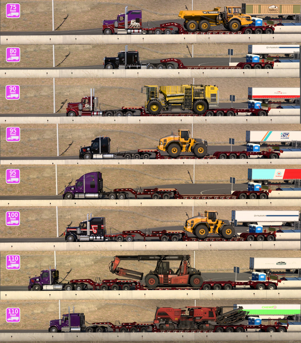
From the top of the chart, trucks are 1. Kenworth W900 tridem lowboy, 2. Peterbilt 389 8x4 low sleeper tridem lowboy, 3. Kenworth W900 8x4 day cab 3+1 trailer, 4. Western Star 49X 8x6 mid-sleeper 3+1, 5. 49X 6x4 sleeper 2+3, 6. Kenworth W900 2+3, 7. Western Star 49X 6x4 day cab 3+3+2, 8. International 9900i 6x4 mid-sleeper 3+3+2 trailer.
Using the long 3+3+2 combination (91 feet long) to meet 110 feet overall limits sleeper choices such as the International 9900i short sleeper shown at the bottom of the chart or a Mack Pinnacle mid-size sleeper. Or consider a day cab. My weight-limit change for the 3+1 trailer means it’s best used with an 8x4 or 8x6 truck. A 6x4 would be better using 2+3 trailer. Same camera view for each shot, but I did not get each truck positioned the same. Use the objects within the scene for comparison.
permissions
Maps created by David G Shrock (DracoTorre.com). You may distribute original images, or link to this page.
other player-created maps
- Printable Road Atlas of ATS by SenseFM (forum.scssoft.com/viewtopic.php?t=306951)
- Trucker Mudgeon’s interactive map (truckermudgeon.github.io)
visit heavy-haul trailers modification page
My World of Trucks profile page
